Sailing Conditions
 he Islands are surrounded by a coral fringing reef, on which the surf pounds down almost all the time.
It is possible to surf at some locations however sailboarding and kitesurfing would probably
not be feasible. The sailing is mainly done in the central lagoon.
The lagoon is several kilometres in diameter, and much of it is only waist
deep.
This can pose some problems in some areas, since it can be quite
shallow (unsailably so) for quite some distance from the shore when
the tide is out.
In the southern half of the atol, most sailing is done on the high half
of the tide. It is usual to sail from the sailing club in this area.
(See this map)
This link
shows tide predictions for the cocos islands (https://www.tideschart.com/Cocos-Islands/).
It is deeper in the northern half of the atol (map).
I have only ever sailed from the sailing club and have no knowledge of good
spots in the northen sector.
The Islands are in the path of SE trade winds for most of the year. The Islands are situated in a cyclone prone
region and are effected by cyclone conditions during the summer months.
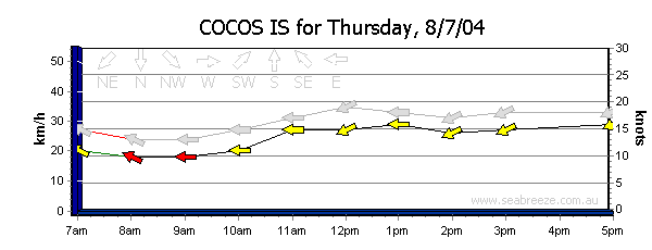
The south east trades are most consistent from June to September, peaking
in August. The wind strengths average 15 - 20 knots, with occasional windless days and windier days.
This graph  (from Seabreeze) shows a typical day.
In August 2001 there was a period of 4 low wind days, an event very unusual according to the
locals.
The area is exceptional for beginner and intermediate sailboarders, and those keen on slalom sailing.
There are no sailable waves, and the depth of tide restrict sailing largely to the high half of the tide.
The area is exceptional for kite sailing, providing good winds and flat water.
The best area for sailing seems to be the Cocos Island Sailing club. There is a good beach on which to rig up
and a good sailable area.
This
page shows some shots of the sailing club region.
 he Islands are surrounded by a coral fringing reef, on which the surf pounds down almost all the time.
It is possible to surf at some locations however sailboarding and kitesurfing would probably
not be feasible. The sailing is mainly done in the central lagoon.
The lagoon is several kilometres in diameter, and much of it is only waist
deep.
This can pose some problems in some areas, since it can be quite
shallow (unsailably so) for quite some distance from the shore when
the tide is out.
In the southern half of the atol, most sailing is done on the high half
of the tide. It is usual to sail from the sailing club in this area.
(See this map)
 (from
(from